
AK Applications: Ecological Applications
| Background |
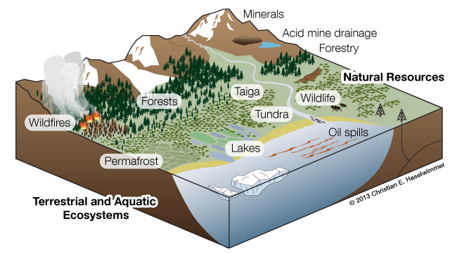
The impacts of predicted global warming are set to occur earlier and with greater intensity at high latitudes and altitudes, which means the State of Alaska is particularly vulnerable. Rising temperatures and decreases in surface albedo when coupled with complex feedback mechanisms cause a variety of climatic, hydrologic, ecologic, and geomorphologic changes that will impact terrestrial and aquatic ecosystems in the state. Airborne HS remote sensing provides unique information concerning terrestrial and aquatic biogeochemical parameters that will contribute to a range of important research activities concerning Alaskas changing sub-Arctic and Arctic ecosystems.
| Permafrost research |
Airborne HS remote sensing of natural vegetation has been used to quantify biophysical parameters such as primary production, Leaf Area Index (LAI), photosynthetic activity, biomass, carbon storage and water fluxes, ecosystem structure, vegetation succession, and for mapping specific vegetation species, and plant functional types. These capabilities lend the technology to permafrost research by facilitating improved mapping and monitoring of permafrost-related vegetation a surface indicator of the presence or absence of near-surface permafrost.
| Greening of Arctic vegetation |
The instrumentation will support long-term research on ecological responses to climate warming in Alaska. A general greening of Arctic vegetation has been documented from 1982-2011 using coarse resolution satellite spectral data; however, the details of changes are not well understood at the local scale. Airborne HS data will provide capabilities for mapping of vegetation species, plant functional types, and biophysical properties with unprecedented detail that will help to unravel both the manifestation and causes of ecological changes.
| ET Mapping |
In the Arctic, where approximately 50% of the annual precipitation leaves the watershed through ET, this information is critical for improved surface energy balance modeling. Airborne HS data will resolve the finer resolution spatial variability in vegetation type, vegetation biophysical properties (e.g. LAI, photosynthetic activity), soil properties, and ET contributing to the long-term modeling efforts for sub-Arctic and Arctic ecosystems.
Read more about our ET mapping efforts at this Alaska ET site.
| Aquatic ecosystems |
Airborne HS remote sensing of aquatic ecosystems enables characterization of the properties of aquatic vegetation, the biological and physico-chemical makeup of the water column, and the properties of the bottom of the water body including substrate and depth. Retrieval of water column properties using airborne HS data has included the measurement of phytoplankton pigments, suspended matter, dissolved organic matter, dissolved organic carbon concentration, and water transparency.
The abundance and properties of Arctic lakes are affected by a warming climate and changing northern hydrological cycle. Arctic lakes are an important component of the northern carbon cycle, particularly when formed in response to permafrost degradation (i.e. thermokarst lakes), as they are associated with the influx of high amounts of dissolved and particulate organic matter. Airborne HS data supports mapping the anomalows dissolved matter.
| Wildfire investigations |
Wildfires in Alaska have responded to changes in climate, and are a vehicle for carbon emissions and large-scale shifts in vegetation composition. Since 2000, interior Alaska has experienced four large fire years in which 17 percent of the landscape burned. By the end of this century, area burned is projected to triple in Alaska for a climate scenario of moderate rates of increase in fossil fuel burning (B1 emissions scenario).
Use of airborne HS remote sensing for wildfire research has included characterization of wildfire fuels, vegetation burn susceptibility, fire temperatures, post-fire conditions, and vegetation regeneration. This MRI will contribute to current and future research on characterizing wildfire temperatures and emissions, and post-wildfire successional patterns.
